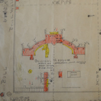
"Hospital Area Columbia” Cropped
Dublin Core
Title
"Hospital Area Columbia” Cropped
Description
Map of Bull Street Campus drawn in 1941 to mark gasoline and kerosine lines. Image has been cropped to show detail of Mills Building and its outbuildings.
Creator
Unknown
Source
Property and land Records ca, 1910-1946, Box 1, Series 190085, Mental Health Commission Record, Location 376J05, South Carolina Department of Archives and History
Date
1941-09-02
Contributor
Digitized by: Kayla Halberg
Equipment: Nikon D3200
Date Digital: 2014-01-31
Equipment: Nikon D3200
Date Digital: 2014-01-31
Rights
This is a digital image of an archival item held by the South Carolina Department of Archives and History. Digitizing Bull Street has made this content available for educational and scholarly purposes.
Identifier
Halberg.06
Maps Item Type Metadata
Physical Dimensions
54cm X 34.5cm
Files
Collection
Citation
Unknown, “"Hospital Area Columbia” Cropped,” Digitizing Bull Street, accessed May 4, 2024, https://www.digitalussouth.org/bullstreet/omeka/items/show/238.

